top of page


Design Samples
These design samples give a glimpse into the process of turning vision into reality. From planting maps to full site layouts, each example shows how we use permaculture principles to create landscapes that are functional, resilient, and full of life.
Each site and owner is unique and so are their obstacles and opportunities. Maps visually display the story of the property: where it begins, what forces are acting through it, where it wants go and how to get there. These maps are accompanied by detailed guides to walk step by step with you down the path to a productive and sustainable future.

Base Map
The beginning of the story. A snapshot of the current condition of the site from existing features to soil conditions.
Energies Map
Working with Nature is the only way to build a sustainable system, using the natural energies of the site to work for you, not against you.


Site Analysis Map
This map gives a visual assessment of the site's obstacles as well as the opportunities they present. This can guide the process from restoration to radiance.
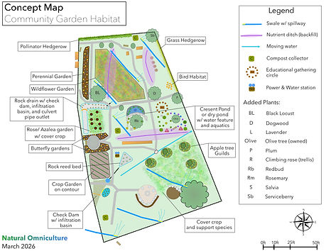
Concept Map
The guiding compass on the journey. This map displays the achievable goal of creating a sustainable and thriving ecosystem that not only supports itself but produces abundance for more than just the people who use it.
Residential:
* Site and client data omitted

Boundary Map
Outlines the property dimensions along with existing physical features and structures. This creates the foundation for all design decisions.
Contour Map
Shows the natural slopes and elevations of the land. These lines help predict water flow and guide the placement of elements like gardens, ponds, or structures.


Sector Analysis
A 360° look at the energies moving through the property — sun, wind, views, noise, wildlife, and more. This helps us position elements in harmony with natural forces (e.g., planting trees to filter wind, using solar energy where sunlight is strongest).
WAS (Water, Access, Structures)
A core framework for functionality. These maps show how water enters and moves through the land, how people access the site year-round, and how structures integrate into the overall design.


Planting Maps
Practical installation guides that show exactly where to place trees, shrubs, and gardens. These maps translate the design into step-by-step planting instructions.
Site Design
The full vision of your property brought together — a complete representation of how all elements interact as a living system. This is both the roadmap and the target design that guides the site toward its long-term potential.

Public Parks & Specialty Designs:
* Site and client data omitted


bottom of page